Spartanburg, South Carolina
| Spartanburg, South Carolina | |
|---|---|
| — City — | |
| Spartanburg, South Carolina Skyline | |
| Nickname(s): The Hub City; Sparkle City | |
| Motto: Service is Our Business | |
 |
|
| Coordinates: | |
| Country | United States |
| State | South Carolina |
| County | Spartanburg |
| Founded | 1831 |
| Government | |
| - Mayor | Junie White |
| Area | |
| - City | 19.2 sq mi (49.9 km2) |
| - Land | 19.2 sq mi (49.6 km2) |
| - Water | 0.1 sq mi (0.2 km2) 0.47% |
| Elevation | 807 ft (246 m) |
| Population (2000) | |
| - City | 139,673 |
| - Density | 2,066.3/sq mi (399.9/km2) |
| - Metro | 280,738 (2,008) |
| - Demonym | Spartans |
| Time zone | Eastern (UTC-5) |
| - Summer (DST) | Eastern (UTC-4) |
| Area code(s) | 864 |
| FIPS code | 45-68290[1] |
| GNIS feature ID | 1250982[2] |
| Website | www.cityofspartanburg.org |
Spartanburg is the largest city in and the county seat of Spartanburg County, South Carolina, United States.[3] It is the second-largest city of the three primary cities in the Upstate region of South Carolina.
Spartanburg is located 98 miles (158 km) northwest of Columbia, 80 miles (130 km) west of Charlotte, and about 190 miles (300 km) northeast of Atlanta. Spartanburg's population was 139,673 at the 2000 census. However, as is typical with South Carolina cities, the urbanized area of the city is much larger at almost 250,000 (according to 2000 U.S. Census Bureau figures), because it is difficult for cities to annex surrounding unincorporated land in South Carolina . It is the principal city of the Spartanburg Metropolitan Statistical Area (population 280,738) which is included in the greater Greenville-Spartanburg-Anderson Combined Statistical Area (population 1,241,618 according to 2008 estimates by the U.S. Census Bureau).
Contents |
History
This region of the Carolina Piedmont was for centuries a cherished hunting ground of the Catawba and Cherokee tribes, which occupied land east and west of this area, respectively. This distant heritage can be glimpsed in some of the natural features.
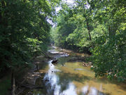
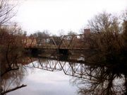
- Lawson’s Fork Creek, a tributary of the Pacolet River, was once known for its plentiful wildlife and crystal clear waters. Parks and woodlands line much of its banks (which lie entirely within Spartanburg County) and rocky shoals and natural waterfalls can be found throughout its course. It stretches from the northern end of the county to the eastern end, where it empties into the Pacolet.
- The Cottonwood Trail is a walking trail that runs along part of Lawson’s Fork located on the Edwin M. Griffin Nature Preserve. The trail includes picnic areas, a raised path over an extensive wetlands area and access to sporadic sandbars. It is used frequently by cyclists, joggers and walkers and is located just east of downtown. Since the Lawson's Fork floodplain is not suitable for development, it has remained home to much of the wildlife for which this entire area was once known. Larger animals that can be found here include the white-tailed deer, raccoon, wild turkey, pileated woodpecker and snapping turtle. [4]
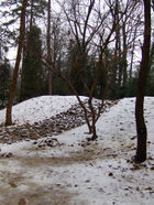
- Hatcher Garden and Woodland Preserve is located in the midst of an urban environment, but is a welcome oasis of natural beauty. The pet project of a retired social activist, Hatcher Garden has been transformed from an eroding gully into a thick woods and flower garden and serves as a haven for birds and other wildlife.
Early European settlers to this area included French fur trappers, English woodsmen, and Scots-Irish farmers. Few remnants survive from these early pioneering days, but traces can be found, particularly in the more rural areas of the county.
- Walnut Grove Plantation, an 18th-century farmhouse, has been diligently preserved by the Spartanburg County Historical Association. The site of a locally-famous skirmish during the American Revolutionary War, it was the home of the Moore family. The plantation lies south of Spartanburg near the town of Roebuck and is open to the public for tours as well as during annual festivals.
- The Seay House, another 18th-century home, is a better representative of the typical pioneer home. Its single stone fireplace and simple construction were common traits associated with farmsteads from this period
- The Price House, the third 18th-century home maintained by the Historical Association, is unique. Its sturdy Flemish-bond brick construction and three stories are less widespread for this area. By carefully examining the original inventory lists of the house, the Historical Association has been able to retrieve period pieces that approximate the original contents of the house.
First established in the 1780s as a courthouse village, Spartanburg is thought to have been named after the Spartan regiment of the South Carolina Militia. The city of Spartanburg was incorporated in 1831, at the time of the 50th anniversary of the Battle of Cowpens, a pivotal battle of the American Revolution that took place only a few miles away. The city’s streets and architectural record reflect the changes of the nineteenth and twentieth centuries.
- Morgan Square, the city’s primary downtown hub, is the original courthouse village. It was founded adjacent to a small spring (now underground) on the western slope of a ridge, which forms the border of the Tyger and Pacolet River watersheds. The square's name derives from Daniel Morgan, the general who commanded the American forces at the Battle of Cowpens. A statue of Morgan was placed in the square in 1881. The oldest existing buildings on the square date to the 1880s. It is now a thriving center for daytime commerce as well as nightlife.
- The Magnolia Street Train Depot is one of the older buildings in the city and stands as a reminder of Spartanburg’s old nickname “the Hub City,” referring to the many transportation routes that connected Spartanburg with cities throughout the region. It is now the home of the Amtrak station, the Hub City Railroad Museum, and the Hub City Farmers' Market.
- Hampton Heights Historic District is the city's oldest intact downtown neighborhood, located a couple of blocks south of Morgan Square. Architectural styles in this neighborhood range from large Queen Anne and Neo-classical homes to cozy early-twentieth century bungalows.
Cotton mills have abounded in the Spartanburg area since 1816, earning Spartanburg the reputation as the "Lowell of the South." Although there were relatively few mills in the area before the American Civil War, new technological advances that simplified the work, northern capital, and out-migration from the poor farms created a wave of postbellum mill development here and in much of the piedmont South. Additionally, the abundant streams and rivers in the area are just beginning their descent towards the lower-lying Midlands region. In many places, these waterways descend abruptly, providing a source for plentiful waterpower. Cotton mills were built along these rivers to harness this power and so began the region’s servitude to King Cotton. These mills, their owners and their laborers dominated the politics and economy of the region for nearly a century. Although nearly all abandoned, many mills remain along the riverbanks, the Piedmont equivalent of Gothic ruins.
- Glendale Mill is located off of Lawson’s Fork Creek southeast of the city. Although gutted by fire several years ago, a few towers and smokestacks remain, providing a dramatic backdrop to the dam, shoals and waterfalls of the creek below. The former company store now serves as the home of the Wofford College Environmental Studies Center.
- Beaumont Mill is located just north of downtown and has recently been renovated to house the Southern Conference headquarters. The adjacent mill village is awaiting designation as a local historic district.
- Converse Mill is located to the east of the city along the Pacolet River and has recently been purchased by a developer whose exact plans for the site have yet to be revealed. The mill was reconstructed in 1903 after a huge flood washed away the original mill.
When the United States entered World War I in 1917, one of the 16 divisional cantonments for the training of National Guard troops, Camp Wadsworth, was established near the town in the vicinity of present Westgate Mall. Large numbers of New York National Guardsmen trained there in addition to many southern troops. During World War II Camp Croft south of the city trained Army recruits. This is now a South Carolina State park with the same name. Some portions of the park contain the original quonset huts (1/2 metal tube structures).
Geography and climate
According to the United States Census Bureau, the city has a total area of 19.2 square miles (49.9 km²), of which, 19.1 square miles (49.6 km²) of it is land and 0.1 square miles (0.2 km²) of it (0.47%) is water.
The average annual temperature is 60 °F (16 °C), with the average January temperature being 40 °F (4 °C) and the average July temperature as 78 °F (26 °C). There are four distinct but not extreme seasons. Average precipitation is 51.3 inches (130 cm) and the average growing season is 231 days.
| Climate data for Spartanburg, South Carolina | |||||||||||||
|---|---|---|---|---|---|---|---|---|---|---|---|---|---|
| Month | Jan | Feb | Mar | Apr | May | Jun | Jul | Aug | Sep | Oct | Nov | Dec | Year |
| Source: http://www.climate-zone.com/climate/united-states/south-carolina/greenville-spartanburg/
http://www.weather.com/weather/wxclimatology/monthly/graph/USSC0325 |
|||||||||||||
Government
The current mayor is Junie White, elected in 2009. The city operates under a Council-Manager form of government in which the mayor and six city council members have equal votes. Council members represent districts within the city and the mayor is elected at large. Council appoints a city manager, who is responsible for the administration of city government.[5]
The County Administration Building (this is the old Sears building which was vacated in the mid-1970s when Sears moved to Westgate Mall and renovated in the late 1980s or early 1990s) is located at 366 North Church Street. It is across the street from the Spartanburg Memorial Auditorium. City Hall is located at 145 West Broad St.
Economy
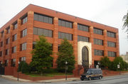
Some of these new developments include a nine-floor, 240-room Marriott, the world headquarters of Extended Stay Hotels, the headquarters of Advance America (see photo), and the headquarters of QS/1 Data Systems. The world headquarters of Denny's restaurants is also located in downtown Spartanburg. Numerous other smaller businesses such as RJ Rockers Brewing Company have also moved downtown as a result of this community-wide effort.
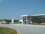
The economy of Spartanburg also benefits from the BMW manufacturing facility located in the western end of Spartanburg County. Manufacturing began in 1996 with certain types of the 3 Series (from the E36 platform) and with the Z3 roadster. However, a year later when the newer 3 Series (E46) platform emerged, BMW decided not to build it at the Spartanburg plant, but instead exclusively manufacture variants of the popular Z3. The plant currently manufactures the X5 SAV and X6 SAC for the world market. As part of an expansion project announced in March 2008, the plant will add about 1,200,000 square feet (110,000 m2) of assembly space, and it will become the home of the next-generation X3 SAV.
Spartanburg is also home to the world headquarters and research facility for Milliken & Company. With over 12,000 associates located at more than 60 facilities worldwide, Milliken is one of the largest privately held textile and chemical manufacturers in the world.
Education
College town
Spartanburg is a College Town[6], and it has six institutions of higher learning:
- The University of South Carolina Upstate (formerly known as University of South Carolina Spartanburg, or USCS).
- Converse College - Founded in 1889, Converse is a comprehensive masters institution with a co-ed graduate school and an undergraduate women's liberal arts college.
- Spartanburg Methodist College - The only 2 year, private, residential college in the state.
- Spartanburg Community College
- Sherman College of Straight Chiropractic - South Carolina's only chiropractic college
- Wofford College - Founded in 1854, Wofford is a Phi Beta Kappa liberal arts college with an enrollment of approximately 1450 students.
Public and private schools
Spartanburg is served by the Spartanburg County School System, which is divided into seven individual districts. Some of the districts share a vocational school. The city of Spartanburg is located in primarily in District 7 of and partially in District 6. The McCarthy Teszler School is a school for special needs that serves the whole county and is physically located in District Seven.
- School District One [7] District One includes Campobello-Gramling, Chapman High, Holly Springs-Motlow Elementary, Inman Elementary, Inman Intermediate, Landrum High, Landrum Middle, Mabry Middle, New Prospect Elementary, and O.P. Earle Elementary.
- School District Two [8] The schools of District Two are Boiling Springs Elementary, Cooley Springs-Fingerville Elementary, Chesnee Elementary, Hendrix Elementary, Carlisle-Foster's Grove Elementary, Mayo Elemntary, Oakland Elementary, Boiling Springs Intermediate, Boling Springs Junior High, Chesnee Middle School, Boiling Springs High 9th grade, Boiling Springs High, and Chesnee High.
- School District Three [9] District Three includes Cannons Elementary, Clifdale Elementary, Cowpens Elementary School, Pacolet Elementary School, Cowpens Middle School, Middle School of Pacolet, and Broome High School. District Three students can attend the Daniel Morgan Technology Center.
- School District Four [10] District Four has four schools: Woodruff Primary, Woodruff Elementary, Woodruff Middle and Woodruff High School. High School students also can attend R.D. Anderson Applied Technology Center to learn vocational skills.
- School District Five [11] Abner Creek Elementary, Duncan Elementary, Lyman Elementary, Reidville Elementary, River Ridge Elementary, Wellford Elementary, Beech Springs Intermediate, Berry Shoals Intermediate, D. R. Hill Middle, Florence Chapel Middle, James F. Byrnes Freshman Academy, and James F. Byrnes High School make up the District Five school system. Vocational school students can attend R. D. Anderson Applied Technology Center.
- School District Six [12] District Six is comprised of Anderson Mill Elementary, Arcadia Elementary, Jesse S. Bobo Elementary, Fairforest Elementary, Lone Oak Elementary, Pauline-Glenn Springs Elementary, Roebuck Elementary, West View Elementary, Woodland Elementary, Fairforest Middle, R. P. Dawkins Middle, L. E. Gable Middle, Dorman Freshman Campus, and Dorman High School. District Six students can attend R. D. Anderson Applied Technology Center.
- School District Seven [13] The schools of district seven are Jesse Boyd Elementary, Chapman Elementary, Cleveland Elementary, Houston Elementary, Park Hills Elementary, Pine Street Elementary, E.P. Todd Elementary, Mary H. Wright Elementary, Carver Junior High, Joseph G. McCracken Junior High, and Spartanburg High School. The Daniel Morgan Technology Center, ZL Madden Learning Center, and Whitlock Flexible also serve District Seven.
Spartanburg is home to Spartanburg Christian Academy, a K-12 private schools in North Spartanburg. [14]
Spartanburg is home to the Spartanburg Day School, a K-12 private school offering The International Baccalaureate in grades K-8 and holds multiple recent state championships in several sports. Its headmaster is Chris Dorrance.
Spartanburg is home to Spartanburg Charter School, a K-6 public charter school that is the only "brick and mortar" charter school in the Upstate. Opened in August 2009, the school will expand; adding a grade level each school year until it is a K-9 program. The school features a reggio emilia approach[15] to their curriculum. [16]
Spartanburg is home to Oakbrook Preparatory School, a K-12 private school that is known for its dedication to excellence in both sports and education. [17]
Spartanburg is home to the main campus of the South Carolina School for the Deaf and Blind. It has five Regional Outreach Centers throughout the state. [18]
Spartanburg is home to St. Paul the Apostle Catholic School which is located in downtown Spartanburg. It is affiliated with the Diocese of Charleston and is K-8. [19]
Healthcare
Spartanburg County’s healthcare is mainly provided by the Spartanburg Regional Healthcare System. Spartanburg Regional is a public, not-for-profit, integrated health care delivery system based in the Spartanburg Regional Medical Center, a 588-bed teaching and research hospital. SRHS provides healthcare services to a five-county area in North and South Carolina, serving an Upstate medical population of more than 300,000 people.
In 1925, Dr. Hugh Ratchford Black opened a 35-bed facility named in honor of his wife, Mary Black. The current Skylyn Drive facility opened in 1968, and today, the campus features a 353,690-square-foot (32,859 m2) modern medical facility. The medical staff consists of more than 350 physicians representing all specialties. Mary Black Physician Group has over 100 employed physicians in more than 30 locations.
Attractions
Spartanburg is home to many events throughout the year:
- The Hub City Farmers' Market[20], an outdoor market held Saturday mornings from 7:00am – 12:00pm during the summer and fall on the grounds of the historic Magnolia Street Train Station, showcasing local (often organic) produce and goods.
- Spring Fling, a weekend festival typically held the first Saturday of May, has many live artists, rides, and other assorted attractions.
- South East Linux Fest - annual, well attended Linux user conference for the South East
- The Annual Sidewalk Arts Show, an open, juried art exhibition held concurrently with The International Festival on the first Saturday in October.
- The International Festival, an event showcasing culture and cuisine from countries around the globe held at Barnet Park on the first Saturday in October.
- Music on Main, a street concert event held every Thursday (April through August) downtown.
- Jamboread Reading Festival
- The Greek Festival, a major street festival that is held in the fall by the local Greek community. It offers Greek food and cultural activities, and is the sister festival to the Greek Festival held every spring in Greenville.
- Dickens of a Christmas, a Victorian holiday event held annually in downtown Spartanburg on the Tuesday after Thanksgiving.
- Festifall, an historical celebration held on the grounds of the 18th-century Walnut Grove Plantation in October, featuring demonstrations and reenactments.
- Taste of the Backcountry, an historical celebration held on the grounds of the 18th-century Price House in April, featuring food samples and demonstrations.
- Spartanburg Bands Together, a music festival at Barnet Park to raise money for good causes.
Other attractions include:
- The Spartanburg Museum of Art[21]
- The Spartanburg Regional Museum of History[22]
- The Spartanburg Science Center[23]
- Ballet Spartanburg [24] which has hosted over 22 national and international ballet companies.
- Several golf courses, including two private 18-hole courses at the Country Club of Spartanburg and the Carolina Country Club.
- The annual Miss South Carolina Pageant
- Cowpens National Battlefield
Sports
Spartanburg is host to the NFL's Carolina Panthers Training Camp each year at Wofford College's Gibbs Stadium.
Historic Duncan Park Stadium was once home to the Spartanburg Stingers[25] in the Coastal Plain League[26] and the Spartanburg Crickets[27] in the Southern Collegiate Baseball League[28] and is the oldest minor league baseball stadium in the country. It now is the home stadium for the baseball teams of Spartanburg High School Vikings.
The Annual Shrine Bowl Of The Carolinas is held each year at Wofford College's Gibbs Staduim. It is a High School Football allstar game played between the top players from South Carolina who meet up and play the top players from North Carolina.
USC Upstate Spartans, Spartanburg Methodist College Pioneers, and the Wofford College Terriers offer a variety of sports for both men and women. Converse College also offers NCAA Division II women's sports teams.[29] Eddie Payne, former coach of Oregon State and East Carolina is the Head Coach of the USC Upstate Basketball team, which enters its first year of Division I Play in the Atlantic Sun Conference
The Southern Conference of the NCAA is headquartered in Spartanburg.
Spartanburg is also located an hour away from the Clemson Tigers and about an hour and a half away from the University of South Carolina Gamecocks.
Spartanburg Parks Commission hosts several travel baseball and softball tournaments each year, helping brand Spartanburg as one of the Southeast's most reputable tournament locations. Tyger River Park, a 13-field mega baseball/softball complex, opens in 2011.
Upward Unlimited, a Christian-based sports organization for kids, is also headquartered in Spartanburg. [30]
Arts and culture
Despite its size as a small city, Spartanburg has, throughout its history, been a fruitful home to a creative community. Cultural events and institutions abound in the city and county and consistently draw large crowds.
- The Chapman Cultural Center[31], Spartanburg's cultural anchor for history, art, theatre, dance, music, and science, is located in a three building complex on the northern edge of downtown. Opened in October 2007, the Center was designed by David M. Schwarz/Architectural Services of Washington, D.C. It houses the Spartanburg Art Museum, Spartanburg County Regional History Museum, Science Center, Little Theatre, Ballet, Music Foundation, and other groups that were formerly located in The Arts Center[32] on South Spring Street. It is owned and operated by The Arts Partnership of Greater Spartanburg, a non-profit organization dedicated to supporting srts and cultural agencies in Spartanburg County.
- The Showroom, the home of Hub-Bub[33], is a new center for progressive arts in the community. It houses a gallery, film screen, stage, and concert venue and is home to a nationally-recognized artist residency program. Hub-Bub is the creative effort responsible for the founding of The Showroom and, as a project goal, seeks to attract and retain creative talent in the community. It was launched in March 2005 by the Hub City Writers Project [34] with assistance from private donors and the city of Spartanburg. The Hub City Writers’ Project has been active since 1995 and serves the community as a local publishing company.
- Converse College[35] is a nationally known four-year liberal arts institution recognized for its strong music and visual art programs. It hosts events open to the community throughout the year. Twitchell Auditorium is also located on the campus of Converse College. Home of the Greater Spartanburg Philharmonic Orchestra, Twitchell Auditorium has served as hosts to other groups such as The Spartanburg All-County High School Band and Boston Brass. Twitchell Auditorium was built in 1899 and renovated for the school's centennial celebration in 1989. Famous for its acoustics, the 1500-seat auditorium is home to a 57-rank Casavant Freres organ with 2,600+ pipes. Theatre Converse puts on several plays a year, and Converse puts on an Opera annually, as well as Opera scenes. Converse also has had major concerts in recent years with such artists as Caedmon's Call, Jason Mraz, Corey Smith, and Colbie Caillat.
- Wofford College[36] is a prestigious liberal arts college with particularly strong Art History and Philosophy departments.
- The Spartanburg County Public Library Headquarters [37], housed in an innovative building on South Church Street is home to a voluminous collection of fiction, nonfiction, children’s literature, A/V materials and items relating to local history and genealogy. Additionally, the library hosts many meetings, concerts and presentations.
- The Spartanburg Memorial Auditorium is located on N. Church Street, across from the municipal building in the northwest end of the city of Spartanburg. The "SMA" has hosted various famous acts such as Bob Dylan, Crosby Stills and Nash, B B King, Billy Joel, David Copperfield, Lewis Grizzard, Harry Connick Jr., Gerald Lavert, Dave Chappelle, Jerry Seinfeld, Phish, A Prairie Home Companion, and many others. Originally built in an Art Deco style and was renovated ca. 2002 including a new facade and backstage with loading area.
Media
- Spartanburg's primary newspaper is the Spartanburg Herald-Journal, a member of The New York Times Company Regional Media Group.[38]
- The Spartanburg Journal is a weekly newspaper that is part of a Community Journal group that also has editions in Greenville and Anderson.
- The Spartan Weekly News is a weekly newspaper with offices located in downtown Spartanburg. The paper covers all of Spartanburg County with an emphasis on the City of Spartanburg, and its coverage focuses on items of community interest and well as news from around the upstate of South Carolina.
- The award winning Hometown News Group has several newspapers throughout the county and upstate region: The Boiling Springs Sentry, The Blacksburg Times, The Inman Times, Spartanburg County News, The Chesnee Tribune, The Middle Tyger Times, The Whitmire News, The Woodruff News, and The Greer Citizen. Aside from local news and sports coverage, the newspapers offer free wedding and social announcements. [39]
- Upstate Link magazine [40] Is a young reader (20s-30s) newsweekly in the Upstate of South Carolina, which includes Greenville, Spartanburg and Anderson. The weekly publication began in January 2004. Link continues to be a print publication, but its Web site ceased operation in 2008. Its new Web site is run by Chicago-based Metromix.
- Root is a non-profit quarterly newspaper written, edited, designed, and published entirely by volunteers. The focus in on stories that convey an "uncommon kindness." Topics generally include animal and eco advocacy, social justice, spirituality, and compassionate use of creative arts.[41]
Spartanburg is part of the much greater Greenville-Spartanburg-Anderson-Asheville DMA which is the nation's 35th largest and is served by the following major network television affiliates:
WYFF 4 (NBC)
WSPA 7 (CBS)- broadcasting from Spartanburg
WLOS 13 (ABC)
WHNS 21 (Fox)
WMYA 40 (My Network TV)
WYCW 62 (The CW Network)- broadcasting from Spartanburg
Transportation
Spartanburg is located along the Interstate 85 corridor, between Charlotte, North Carolina and Greenville, South Carolina. Two spurs of Interstate 85 are located in the area: Interstate 585, which morphs into N. Pine Street/US Highway 176. Interstate 26 runs through the county that connects Columbia, South Carolina and Asheville, North Carolina.
Spartanburg has access to two airports.
- The Greenville-Spartanburg International Airport (GSP) lies mostly in Spartanburg County in suburban Greer, and it serves Greenville as well as Spartanburg.
- The Spartanburg Downtown Memorial Airport (SPA) is owned and operated by the City, and lies south of town.[42]
Spartanburg is served by the Spartanburg Area Regional Transit Agency or SPARTA. SPARTA serves the City of Spartanburg and the surrounding urbanized area with 8 routes leading to a wide variety of destinations.[43] The new SPARTA Passenger Center is located at 100 North Liberty St.
Amtrak's Crescent train connects Spartanburg with the cities of New York, Philadelphia, Baltimore, Washington, Greensboro, Charlotte, Atlanta, Birmingham and New Orleans. The Amtrak station is situated at 290 Magnolia Street.
Demographics
- See also: Demographics of Spartanburg County
As of the census[1] of 2000, there were 39,673 people, 15,989 households, and 9,721 families residing within the Spartanburg city limits. The population density was 2,066.3 people per square mile (799.9/km²). There were 17,696 housing units at an average density of 923.9/sq mi (356.8/km²). The racial makeup within the city limits was 49.55% African American, 47.15% White, 0.18% Native American, 1.33% Asian, 0.06% Pacific Islander, 0.76% from other races, and 0.96% from two or more races. Hispanic or Latino of any race were 1.78% of the population.
There were 15,989 households out of which 28.9% had children under the age of 18 living with them, 34.0% were married couples living together, 23.0% had a female householder with no husband present, and 39.2% were non-families. 34.0% of all households were made up of individuals and 13.2% had someone living alone who was 65 years of age or older. The average household size was 2.33 and the average family size was 3.00.
In the city the population was spread out with 25.2% under the age of 18, 12.2% from 18 to 24, 26.6% from 25 to 44, 20.6% from 45 to 64, and 15.4% who were 65 years of age or older. The median age was 35 years. For every 100 females there were 79.6 males. The median income for a household in the city was $28,735, and the median income for a family was $36,108. Males had a median income of $30,587 versus $23,256 for females. The per capita income for the city was $18,136. About 19.4% of families and 23.3% of the population were below the poverty line, including 34.6% of those under age 18 and 15.4% of those age 65 or over.
List of neighborhoods
|
|
Notable natives and residents
- John Alexander, born in the Spartanburg District, United States Congressman from Ohio[44]
- Pink Anderson (1900–1974) -- blues musician; inspiration for the "Pink" in Pink Floyd.
- Art Fowler (1922–2007) -- pitcher and pitching coach in Major League Baseball.
- David Ball (1953--) -- country musician.
- Kate Barry (1752–1823) - scout and heroine of the revolution, she warned of the British attack at Cowpens
- Elizabeth Bennett (1968-) - psychologist
- Joe Bennett - Lead singer and guitarist from the 1950s Rock 'n Roll band "Joe Bennett and the Sparkletones".
- James Francis Byrnes (1882–1972) - lawyer, congressman, senator, Supreme Court Justice (only person to step down off the bench for another federal post—head the wartime Office of Economic Stabilization), advisor to FDR, Secretary of State to Truman, Governor of SC
- Wilson Casey - syndicated newspaper columnist
- Marshall Chapman - singer songwriter
- Buck Trent - Country Music instrumentalist who accompanied Porter Wagoner & Dolly Parton among others
- Grits Gresham - sports journalist and host of ABC's The American Sportsman from 1966–1979
- David Daniels (1966--) - counter-tenor
- Stephen Davis - American football running back
- Hank Garland (1930–2004) - Nashville session guitarist who accompanied Patsy Cline & Elvis Presley
- Mark Hammond (1963-) - South Carolina Secretary of State
- Lee Haney (1951-) - Eight time Mr. Olympia record holder
- Dennis Hayes (1950-) - inventor of the Hayes modem
- Walter Hyatt (1950–1996) - country musician and songwriter
- Joseph T. Johnson (1858–1919) - United States Representative from South Carolina
- Kenneth Law - cellist
- Donald Lawrence - Gospel artist
- Marshall Tucker Band - Southern rock band featuring George McCorkle, Doug Grey, Jerry Eubanks, Toy Caldwell, Tommy Caldwell, et al
- Marcus McBeth - baseball player
- Chuck McCorkle (1945–2009) - Southern rock musician and founding member of the Erly Wildes Band
- Roger Milliken (1915-) - billionaire owner of the largest privately held textile manufacturing firm in the world (Milliken & Company)
- Bud Moore - NASCAR team owner/crew chief
- Thomas Moore (1759–1822) - United States Congressman from South Carolina
- Samuel J. Nicholls (1885–1937) - United States Representative from South Carolina.
- Cotton Owens NASCAR team owner/crew chief
- David Pearson (1940-) - Race car driver
- Gianna Rolandi - internationally renowned operatic soprano
- Donald S. Russell (1906–1998) - former South Carolina governor, president of the University of South Carolina, US Senator, and member of the US 4th Circuit Court of Appeals
- Archibald Rutledge (1883–1973) - South Carolina poet laureate, resided in Spartanburg for about 20 years
- T. Camden Shealy (1790–1900) - Navy veteran of the War of 1812 and litigator of regional repute.
- Ira Tucker (1925–2008) - lead singer of legendary gospel group, the Dixie Hummingbirds
- William 'Singing Billy' Walker (1809–1875) - singing teacher. He produced shape note hymnbooks, including many of his own tunes: The four-shape The Southern Harmony, and Musical Companion (1835) and seven-shape The Christian Harmony (1866) were both widely used across the South
- General William C. Westmoreland (1914–2005) - served in World War II and the Korean War and was senior US military commander in Vietnam. Second Eagle Scout in Troop 1 (BSA)
- Celia Weston - actress, "Junebug", "In the Bedroom."
- Mark R. Johnsen (1962-) - founder and owner of Spartanburg's first and only brewery, RJ Rockers Brewing Company.
- Jack Smith - Nascar driver
- Angela Nikodinov - US Figure Skater
References
- ↑ 1.0 1.1 "American FactFinder". United States Census Bureau. http://factfinder.census.gov. Retrieved 2008-01-31.
- ↑ "US Board on Geographic Names". United States Geological Survey. 2007-10-25. http://geonames.usgs.gov. Retrieved 2008-01-31.
- ↑ "Find a County". National Association of Counties. http://www.naco.org/Template.cfm?Section=Find_a_County&Template=/cffiles/counties/usamap.cfm. Retrieved 2008-01-31.
- ↑ [1]
- ↑ [2]
- ↑ "College Town"
- ↑ School District One
- ↑ School District Two
- ↑ School District Three
- ↑ School District Four
- ↑ School District Five
- ↑ School District Six
- ↑ School District Seven
- ↑ [3]
- ↑ Reggio Emilia approach
- ↑ [4]
- ↑ [5]
- ↑ [6]
- ↑ [7]
- ↑ The Hub City Farmers' Market
- ↑ The Spartanburg Museum of Art
- ↑ The Spartanburg Regional Museum of History
- ↑ The Spartanburg Science Center
- ↑ Ballet Spartanburg
- ↑ Spartanburg Stingers
- ↑ Plain League
- ↑ Crickets
- ↑ Collegiate Baseball League
- ↑ [8]
- ↑ [9]
- ↑ [10]
- ↑ [11]
- ↑ [12]
- ↑ [13]
- ↑ [14]
- ↑ [15]
- ↑ [16]
- ↑ GoUpstate.com
- ↑ [17]
- ↑ Upstate Link magazine
- ↑ KinderCarolina.org
- ↑ Spartanburg Downtown Memorial Airport
- ↑ Spartanburg Area Regional Transit Agency
- ↑ Who Was Who in America, Historical Volume, 1607-1896. Chicago: Marquis Who's Who. 1963.
Further reading
- Cooper. Peter (1997). Hub City Music Makers. Spartanburg, S.C.: Holocene Publishing. ISBN 0-9638731-9-9.
- Landrum, J.B.O. (1900). History of Spartanburg County.
- Racine, Philip N. (1999). Seeing Spartanburg. Spartanburg, S.C.: Hub City Writers Project. ISBN 1-891885-10-3.
- Teter, Betsy Wakefield (Ed.) (2002). Textile Town: Spartanburg, South Carolina. Spartanburg, S.C.: Hub City Writers Project. ISBN 1-891885-28-6. Pp. 346. 40 authors provide a detailed community study, using oral histories, letters, and 200 illustrations and photographs. Central themes include labor strikes, family life in the mill villages, Depression-era hardships, race and desegregation, the boom of WW2 production, and late-twentieth-century deindustrialization.
- WPA (1939). History of Spartanburg County.
External links
- City website
- Spartanburg Tourism Commission
- Spartanburg Herald-Journal
- U.S. Bureau of Labor Statistics' Metropolitan and Nonmetropolitan Area Occupational Employment and Wage Estimates for Spartanburg, SC, May 2007
|
|||||||||||||||||||||||

|
||||||||||||||||||||||||||